

Stage 1 Titled
Stage 3 january 2027
Corner Murchison-Tatura Road & Murton Road TaturaSilkwater plains tatura
[ OVERVIEW ]
Silkwater Plains is an established residential community on the southern edge of Tatura, where homes are already built, families have moved in and the estate continues to take shape.
Land is available across two stages, so you can build now or plan ahead. The final Stage 1 lot is fully titled and ready to build on, while Stage 3 offers lots from 556m² with titles anticipated in January 2027.
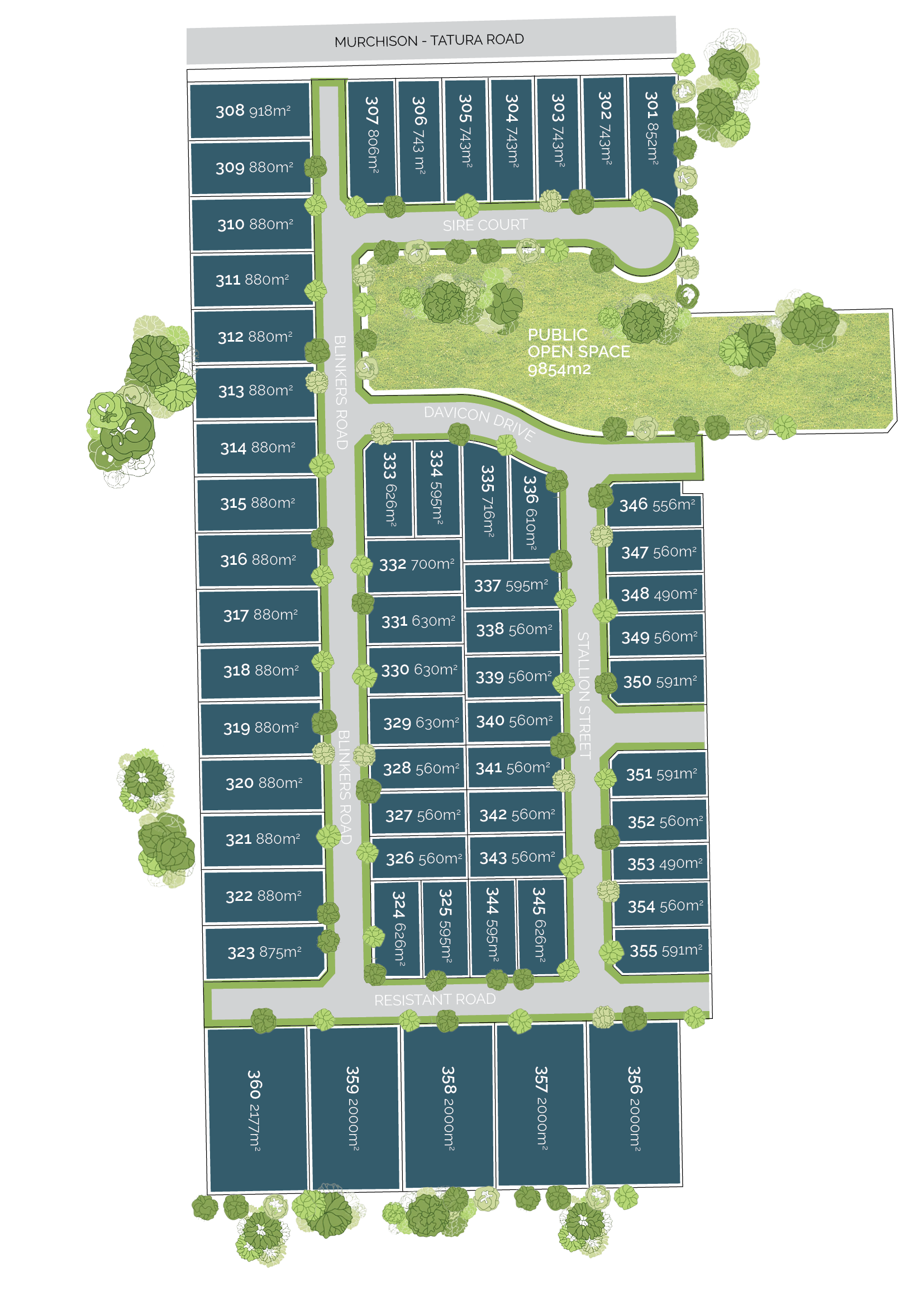
Stage 3 is the newest release, with titles anticipated in January 2027. Lots are set around a central 9,854m² reserve, and a limited number of park-front lots on Davicon Drive look out across open space.
Lot sizes range from approximately 556m² to over 2,000m², with prices from $241,000 to $345,000. That range covers everything from an easy-care family home site to a large lifestyle allotment.
Located minutes from Tatura's town centre and 18km from Shepparton, in the heart of the Goulburn Valley, Silkwater Plains offers space, connection and everyday convenience.
Development Details
Stage 1 - Titled
Stage 3 - january 2027
Expected Titles
Lot Sizes
Stage 1 - 2000m2
stage 3 - from 556m2
Pricing
From $241,000
[ Details ]
The masterplan
An Established Neighbourhood, Ready for What’s Next
The Silkwater Plains masterplan is designed to balance open space, connectivity and flexibility across each stage of the estate. A clear, structured layout is anchored by central green space, creating a natural focal point while maintaining flow through the community.
A mix of lot sizes — from traditional residential blocks to larger-format allotments — supports a wide range of home designs, ensuring the estate caters to different buyers and life stages while maintaining a cohesive streetscape.
-
At Silkwater Plains, lots are now available from $241,000, with opportunities across two stages within an established community.
SEE ALL PRICING HERE -
At Silkwater Plains, lot sizes range to over 2,000m², offering both traditional and large-format options.
-
Follow the latest construction updates and see Silkwater Plains taking shape. Limited lots remaining across earlier stages.
VIEW THE LATEST PROGRESS
DISCLAIMER:
All information is subject to change without notice. Images are artist impressions only. Lot sizes subject to survey and approval.


